Grid Sampling vs. Zone Sampling
Mar 10, 2019

When looking into a precision ag program, there is often the question of "what’s the difference between grid sampling and zone management (or zone sampling)". The answer is not always as easy just one or the other. Both can be very useful and give tremendous insights into our field and what its limiting factors might be.
Grid Sampling
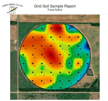
Grid sampling has been around for many years and is probably the most widely used. Once a field is defined, a "grid" is laid out with a mapping software based on a predetermined size. Generally, 2.5 acre grids are used, though any acre size can be done (we offer 1.5, 2.5, 5, and 10 acre grids). The size of the grid can depend on what your trying to correct or what your price needs are. Something to remember is that anything much below 1.5 acre is very hard for equipment of today to accurately apply products.
Once the grid is laid out, soil samples are collected at each point. We like to collect about 15 samples from each point to get a good representation of that grid. After all the samples have been collected a complete lab analysis is done and maps of each nutrient are returned to the grower. After consulting with an agronomist, appropriate action can be taken.
So, what can we do with this information? Based off the results, fertilizer products can be applied to correct or fertilize for each nutrient based off a general yield goal. Correcting pH is the most commonly sought-after information when grid sampling is done.
Zone Management
Zone management is not exactly something new either. People have been using zones based off SSURGO soil data for some time now. Advancements in technology have allowed for other more accurate types of zones to be made. A few of those methods are satellite imagery, yield data, or EM/EC data.
Satellite and yield data are simply used to define the most and least productive areas of the field. When we build zones based from satellite imagery from the R7 Tool by Winfield United, we can build anywhere from 2-12 zones in a field. Generally, we like to keep it around 3-5 zones.
When we build zones from EM/EC data, a Veris cart is pulled across the field on 60' swaths. This cart uses electric current determine soil texture at 2 different depths, 0-12" and 0-36". After a field has been logged, the data is processed in FieldReveal and layered with RTK elevation and satellite imagery and/or yield to identify zones. FieldReveal has definitions for 12 different zones (each field averaging 5-7 zones) that tell us that zones soil type and productivity level.
After the zones are set up, a composite soil sample of each zone is done. Based off the results we can variable rate seed and fertilize based on a yield goal for each zone.
The Difference
Now that we understand the differences between grid vs. zone, we can look at what’s best for the current situation. Correcting a major deficiency/pH issue or getting a baseline on a newly acquired piece of ground are the main advantages of grid sampling. The drawback is the grids will change over time and a field needs to be re-gridded after a few years.
Another drawback of grid sampling comes with having a flat yield goal across the field. With the variability in the fields, many areas of the field can still be over fertilized.
Zones on the other hand, can tend to have a higher price the initial year. But is much lower priced in subsequent years. Once the zones are set up, they can be applied long term allowing it to be much more sustainable.
The Great Bend Co-op Value
At Great Bend Co-op, we now offer the Premier Acre program. This is a complete precision ag program that offers grid or zone management over the course of 4 years. This allows a grower to get into a program at a much lower price.
Please contact us about any of our precision ag services.
